
Forums
I am in the process of documenting several properties for my ancestor who lived in an area within multiple county boundary changes. I want to include images from the Bureau of Land Management website that shows where the properties are (present-day), but I'm not quite sure how to cite the image. This is my initial thought for the citation:
Hugh Chandler (Independence County), certificate no. 913, 1 November 1835, land description map depicting location; "land patent search," images, General Land Office Records (https://glorecords.blm.gov: accessed 28 September 2022).
I would appreciate any thoughts.
Upload a document
Kristina, there are a few…
Kristina, there are a few things missing. I know you have Evidence Explained, so I'll ask if you've had a chance to review EE 11.30 at pp. 590–91. That shows the essentials for maps we download from glorecords.blm.gov.
I have reviewed 11.30, which…
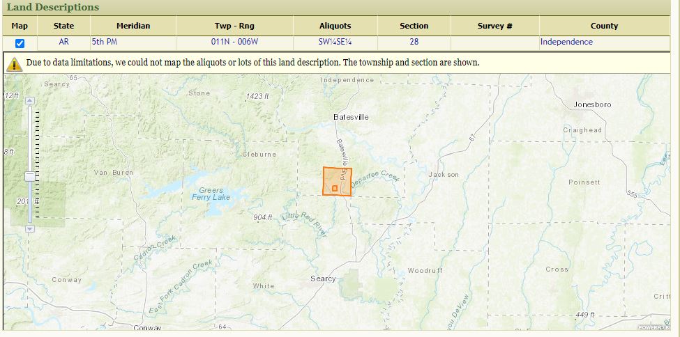
I have reviewed 11.30, which is for the survey maps. I am trying to cite something different. After going to the "Patent Details" page, there is an option under "Land Descriptions" to check a box to see where the property is located in the present day. I am trying to cite that map (powered by ESRI).
Kristina, let’s walk this…
Kristina, let’s walk this through from the standpoint of someone who must use your citation to locate the map.
When the user of your citation clicks on your URL (https://glorecords.blm.gov), there is no place to type in “Hugh Brown Chandler,” or “Independence County.” They can’t type in “Certificate No. 913.” There is actually no current option called “Land Patent Search." So how does the user get to the map from which you made your jpg?
The search form is at www.glorecords.blm.gov/search/default.aspx/. From there, we point the path for the user to follow. At this URL, the first thing that the citation’s user must choose is “state.” They can’t just enter a name or a county or a certificate number. So our citation has to identify the state (that’s one of the missing essentials I referred to earlier).
Recognizing the landmark names on your map snippet, I typed Arkansas, Independence County, and Chandler: Hugh Brown (that being the name you’ve assigned to the document image that does not itself show a name). I received a message, “No matching records found.”
I then tried this same path using variations of the name and got hits for both “Chandler, Hugh” and “Chandler, Hugh B.” The entry for “Hugh” is the one that matched the legal description on the map snippet.
At that point, the citation’s user will wonder: Where do I go from here to find that map? There’s nothing that says “certificate no.” as worded in the citation. The only clickable option is “Accession No.” This is the critical identifier. GLO/BLM has issued a kajillion certificates that carry "No. 913" because each land office had its own set of numbering and different types of patents had their own numbering scheme. But the Accession No. assigned by BLM is the unique identifier.
Once we click on that identifier, we see much data about the land and the transaction. Below it, we see the ESRI map, right there on the same page.
To summarize, thus far:
All of this fits the framework of the basic BLM database entry at 11.27. Applying that pattern for your details would give us this for citing the patent.
Bureau of Land Management, “Search Documents by Type: Patents,”* database with images, General Land Office Records (www.glorecords.blm.gov/search/default.aspx : 6 October 2022), Hugh Chandler (Independence County, Arkansas), accession no. AR0580__.116 [to which you can add the specific STR data if you wish].
Then to cite the map that is on that same web page, given that the map is not titled, we just create a generic reference, say:
Bureau of Land Management, “Search Documents by Type: Patents,” database with images, General Land Office Records (www.glorecords.blm.gov/search/default.aspx : 6 October 2022), Hugh Chandler (Independence County, Arkansas), accession No. AR0580__.116, ESRI map enlarged 10X
*Note that the wording has changed since the EE example was first created. Then, the database’s search page was titled “Land Patent Search.” Today it’s “Search Documents by Type” with five options thereunder: Patents, Surveys, LSR, CDI, Tract Books.
Always, when these changes occur, we use what we see there on the screen, as opposed to following exact language in some citation guide.
Thank you for pointing out…
Thank you for pointing out the missing information from my original citation. Because my ancestor obtained multiple properties in Arkansas that were impacted by multiple county border changes between 1836 and 1883, locating these lands on present-day maps is very helpful.
After reading your comments, I am working through the process a bit more. I can access the certificate via different websites (Ancestry and General Land Office Records); therefore, my citation to the land certificate focuses on the document image rather than the websites.
The Ancestry database has search fields for both the document [certificate] number and accession number. The General Land Office Records database includes a search field for the document # under "Miscellaneous" but not a search field for the Accession number. However, clicking on the accession number is how you get to the document image, so I now see the importance of including that number. The accession number is not on the document image itself, so would it be appropriate to add it after the specific information from the document? Depending on where I access the image, I think either of these citations could work.
Because the map I want to cite is only found through searching the database, I need to focus on the website and how to get to the map.
"Search Documents by Type: Patents,” database with images, General Land Office Records (https://glorecords.blm.gov: accessed 28 September 2022), Hugh Chandler (Independence County, Arkansas), certificate no. 913, 1 November 1835, Accession no. AR0480.116, ESRI map enlarged 10X.
I would appreciate any additional thoughts on this.
Kristina, all three…
Kristina, all three approaches work. EE recommends the third (and the same approach at Ancestry) for the very reason you cite before the third example: We have to access these through the databases and we do not have the complete information needed to cite the original document in a standalone layer.
For the certificate, would…
For the certificate, would you also recommend including the land office information as shown for the cash entry file in 11.23?
I'm running into boundary changes that complicate things just a bit. Township 10N, Range 8W, in Arkansas, was originally part of White County and is now part of Cleburne County. Certificates show White County. However, the BLM database shows "Cleburne, White" county for Sections 34-36 and the other sections are indexed under Cleburne County. I'm thinking a notation is needed for clarification.
"Search Documents by Type: Patents," database with images, General Land Office Records (https://www.glorecords.blm.gov: accessed 13 October 2022), Carter J. Chandler (Cleburne, White County), cash entry certificate no. 13384, Batesville, Arkansas, Land Office, Accession no. AR0710.437. This tract (W1/2 of SW1/4, Section 36, Township 10N, Range 8W) was originally part of White County and is now part of both Cleburne and White counties.
Kristina, my apologies for…
Kristina, my apologies for not seeing this response when it came in. I've been too buried in a project of my own.
The changing landscape, historically and technologically, suggests flexibility when citing this website.
If we cite the search page …
Then citing the certificate/accession/patent number is definitely not the best approach. The basic query boxes call for state:county and name, or the legal land description.
The page also has options for "Document #" but a tract of land can have different document numbers and users typically don't know which one the site is asking for. Also, using your example, if I select Arkansas and type in your “Doc. 913," I get 15 different hits for tracts of land in Arkansas that carry the same document number. Conversely, the Accession Number is the unique number, but it we put the accession number for Hugh Chandlers tract of land, we get an error message.
Citing the exact URL …
This is the most precise approach. Our citation might then include the accession #, the section-township-range-meridian, the current county ID, and (if we wish) the date.
Coincidentally, the project I’ve been deep into this past month includes quite a few citations to this site and its various offerings. I have not found that either approach works well in all cases.
Elizabeth
If I may ask a two…
If I may ask a two associated questions...
In the discussion I noted that, despite a search-form being used, the search-terms are never identified as such. However; I can see that the required search-term information is actually present in the balance of the citation. I take it that this means that one does not need to explicitly state which information serves as parameters in the search. Is this correct?
Based on the previous discussion, I will assume that the answer to my question is, yes.
If the search-engine only provides access to the start of a set of browsable images (eg. the start of a portion of an imaged film), one must still browse and record the image number of the item-of-interest. A case in point is the method of accessing the État Civil records of the Archives of Paris. This is the situation for which I could use some advice...
Usually; the image number belongs in that portion of the citation that addresses locating the image, not with information located on the image itself (Adhesion principle???). So; my best guess is that the resulting citation must actually look something like the following. However; the the image number still feels out-of-place.
Translated for your convenience in commenting:
France, "Actes de naissance (1860-1924), mariage (1860-1947) et décès (1860-1986)", database with browsable images, Archives de Paris (https://archives.paris.fr/s/4/etat-civil-actes/? : downloaded 29 January 2023), image 24, births in the 13th arrondissement, for the year 1919, act 3007, drawn up 06/09/1919, for Garnier (Raymond Lucien Armand), born 4 September 1919; cites archival reference "13N 426" [Civil Register, Births, Paris 13, 2 August 1919 to 30 September 1919], Paris 19 (Buttes-Chaumont), Paris, Île-de-France, France.
Untranslated from my rough research notes (if you prefer):
France, "Actes de naissance (1860-1924), mariage (1860-1947) et décès (1860-1986)", base de données avec images navigables, Archives de Paris (https://archives.paris.fr/s/4/etat-civil-actes/? : téléchargé le 29 janvier 2023), image 24, naissances dans le 13e arrondissement, pour l'année 1919, acte 3007, dressé le 06/09/1919, pour Garnier (Raymond Lucien Armand), né le 4 septembre 1919; cite la référence archivistique "13N 426" [État Civil, Naissances, Paris 13, 2 août 1919 au 30 septembre 1919], Paris 19 (Buttes-Chaumont), Paris, Île-de-France, France.
Yes, History-Hunter. That…
Yes, History-Hunter. That works.